In the state of New York, more than 100 public access sites, including parks, preserves, boat launches, and fishing piers along the shores of the tidal Hudson provide outstanding recreational, scenic, and economic value to the Hudson Valley. However, climate models project the estuary’s water-levels may rise several feet by the end of this century, threatening the condition and viability of many of these shoreline facilities.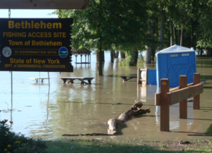
Sea-level has risen six inches in the last 50 years, and today, low-lying sites regularly experience flooding during exceptionally high tides or periods of intense rainfall. Hurricane Irene, Tropical Storm Lee, Superstorm Sandy, and seasonal nor’easters destroyed infrastructure, caused erosion, and damaged recreational resources, and more frequent and intense storms are predicted to occur in the future.
To assist owners and managers of public river access sites adapt their facilities to existing and predicted flooding, New York’s Department of Environmental Conservation is offering strategies and solutions in “The Flood Resilience Handbook for Public Access Sites along the Hudson River.” The handbook provides guidelines to begin planning for resilience and reduce damage, costs, and other consequences associated with flooding and the effects of climate change. By planning and implementing resilience strategies and public outreach plans, site managers can address vulnerabilities and continue to provide access under changing conditions.
While many aspects of this handbook are relevant to river access sites elsewhere, the geographic focus is on the Hudson River estuary and its tidal tributaries in the 10 counties of the Hudson Valley: Albany, Columbia, Dutchess, Greene, Orange, Putnam, Rensselaer, Rockland, Ulster, and Westchester.
The Flood Resilience Handbook was produced by WSP engineering, with funding from NEIWPCC in partnership with DEC’s Hudson River Estuary Program.