
Sifting through old paper files in the records room of a Town Hall basement, NEIWPCC Environmental Analyst Mike Forgeng is searching for drinking water well logs, groundwater assessments, and other geologic records to better understand the area at hand. This data, in addition to what Forgeng can find through public and state resources, will become the foundation of a model he builds to simulate groundwater flow for a drinking water source protection plan.
Forgeng creates these plans for New York’s Drinking Water Source Protection Program (DWSP2), a locally led program supported by the state departments of environmental conservation (NYSDEC) and health (NYSDOH). By participating in the DWSP2, municipalities receive free technical assistance – such as from Forgeng – to develop and implement community-specific drinking water source protection plans.
Source water is a supply that provides drinking water to a public system. These sources can encompass surface water, such as rivers and lakes, as well as groundwater from bedrock or unconsolidated aquifers – those that consist of sediments like sand and gravel. By understanding the geographical area that contributes to a source, communities can then begin to define water quality threats. Proactively protecting drinking water sources is an effective management strategy because once contaminated, it can be very difficult and costly to remediate.

Working as a hydrogeologist, Forgeng implements various source water assessment and protection projects. This work includes evaluation and delineation, and – unique to his more technical role – he compiles large quantities of data to develop sophisticated groundwater flow models.
“Our team of technical assistance providers are very capable of delineating the land areas that contribute to surface water,” said NEIWPCC and NYSDOH Program Manager Ryan Bell, who oversees Forgeng. “Identifying the contribution areas for groundwater, however, can be much more complicated. So, we rely on Mike’s modeling expertise to help when we have participating communities whose source water is stored below the surface in aquifers.”
Most New Yorkers get their drinking water from surface water sources, such as from the Ashokan Reservoir in the Catskill Delaware Watershed. However, approximately one quarter relies on groundwater sources, which is where Forgeng’s expertise comes into play if the community participates in DWSP2.
“A model is only as reliable as the real-world observations it references,” said Forgeng, “and limits on our program’s capacity to collect real-world data can be an obstacle.” Forgeng has been in this position for nearly five years and emphasized the importance of locating existing data with stakeholders early in the DWSP2 planning process, stating that municipalities often dig up useful records they did not know existed.
Once Forgeng gathers sufficient data, he uses groundwater modeling software called MODFLOW to reconstruct the geology around wells drilled into the aquifer – this land area is known as a wellfield. The software simulates how groundwater travels through the aquifer to the well intakes.
Groundwater movement is primarily influenced by the aquifer material, such as bedrock or unconsolidated sediment; the local geology, including the depth of the bedrock, extent of fracturing, and presence of carbonates; and precipitation. He says that New York’s post-glacial valley fill aquifers are highly variable and difficult to extrapolate with limited data, so creating groundwater models in this region can be challenging.
The models take into account numerous data sets, such as geologic descriptions of aquifers, water level measurements, precipitation rates, and pumping (or withdraw) rates. The data are used to estimate the time of travel for simulated particles in groundwater. This helps communities identify “critical areas” to protect – often defined as an area around a wellfield that contributes water to the well intakes in a set number of years.
Additionally, the models can help identify what potential contaminant sources could influence the wellfield – nutrients from runoff or agriculture, petroleum products, road salt, and PFAS – and predict how and where they may move through the aquifer. If a community finds a certain contaminant in their well water, the model can help delineate the area the contaminant likely came from, which in turn can support remediation efforts. Forgeng explains results to the DWSP2 stakeholders and then references the model to define protection areas for their source water protection plan.
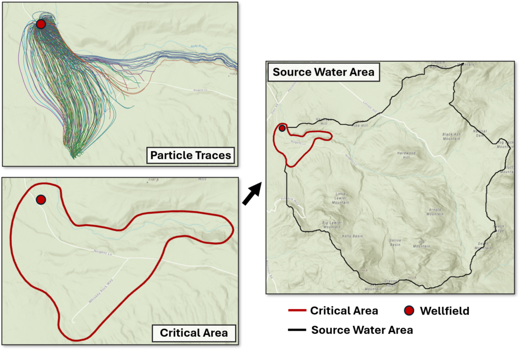
“We also document and map out potential contaminant sources within defined DWSP2 protection areas for the stakeholders to reference,” said Forgeng. “Then we build protection and management strategies tailored to the drinking water concerns of that community – concerns like road salt contaminating wellfields or rising PFAS concentrations. There is a wide range of issues affecting source water quality across New York.”
Protection and management methods include developing land use tools, such as specific maps or datasets to help inform zoning or Critical Environmental Area designation; implementing water quality monitoring; and evaluating regulated potential contaminant sources within a source water area. The DWSP2 technical assistance providers help municipalities determine feasible implementation actions and an associated timeline, as well as provide guidance on funding sources to cover project costs during implementation.
“The goal is really to prevent [contamination] and not focus on specific contamination events,” said Forgeng. “We work on things like buffer remediation and land acquisition, but also more systematic efforts like updating municipal comprehensive plans and helping municipalities strengthen relevant emergency notification systems. A key part of this program is also to help communities identify funding opportunities for each specific priority.”
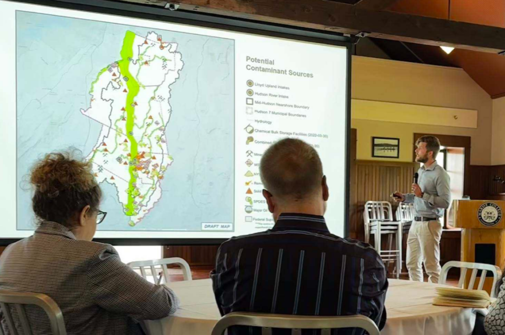
Forgeng, who holds a master’s degree in geosciences specializing in hydrogeochemistry from Pennsylvania State University, has a strong technical background. While essential for the modeling component of his role, he notes how much his work relies upon effective communication and the ability to navigate social obstacles in a productive way. These skill sets come into play during stakeholder meetings.
“Mike is very technical,” said Bell. “But he is also very skilled at translating complex geological models with visual presentations that make the information more accessible for stakeholders.”
As a community-driven process, engaging a diverse group of community members is essential. The stakeholder group often includes local governing officials, water operators, agricultural representatives, environmental advocates, community members, and representatives from the local or county health departments, local universities, and highway department.
“The key is we have to build a really competent stakeholder group of motivated people,” said Forgeng. “And then they, with these tools and connections that we help them develop, can work to improve their drinking water source in a more meaningful way.”
Forming a resilient and self-motivated stakeholder group can be an intensive process. Forgeng says that meetings can sometimes be a place where community members voice strong views and have blunt conversations, but he’s found that he gets a lot out of guiding tense situations into a productive direction – especially when the plan is strengthened as a result.
Bell explains, “Mike engages municipal leaders and other key stakeholders, building trust and strengthening partnerships. Even when tensions are running high, Mike leverages his communication style and geologic expertise to proactively diffuse politically sensitive situations and bridge the gap between technical data and local governance to help communities make informed decisions about their drinking water sources.”
The DWSP2 program continues to grow, adding 16 municipalities in 2026 for a total of 117 participating since the program launched in 2021. Forgeng and other technical assistance providers try to set the municipalities up for success, empowering them to implement their own unique source water protection measures while learning from the plans developed by other communities.
“I found out that I get a lot out of the social side of things,” said Forgeng. “I feel amazing after those kinds of meetings – it’s a counterbalance to the technical side. I like keeping the groups functional, and building and watching them become capable of taking the initiative for themselves – it’s the best feeling in the world.”
To learn more about the DWSP2 program, view the Seven Pillars of the Drinking Water Source Protection Program article, or explore the New York State website.